Mildenhall,
Town in Wiltshire
Near Marlborough, County of Wiltshire: Find Mildenhall. Pronounced "Minal".
Minal? Why that pronunciation for a word that sounds a three syllable Mil den hall. And where a family emigrated at the time of William Penn to Pennsylvania, the Mendenhalls. See
Mildenhall - Mendenhall. Wiltshire at FN 1 there for Joseph Mendenhall.
A. The Name Mildenhall pronounced Minal.
Ask Helen Scholes, calligrapher, lettering artist, illustrator, and see her work at
Pen and Ink Calligraphy at ://www.penandinkcalligraphy.co.uk/contact.html/
We are starting with the research on a print by Ms. Scholes, with calligraphy and illustrations: background legwork by one Richard Westall, who died in 1998. Look at the calibre of the xalligraphy by Helen Scholes, a local artist. All this in a print series dated 1999. She dedicates the series to Mr. Westall.
Here is a fair use tiny portion of the print, showing the town area and immediate fields around.
Ms. Scholes has appropriately pointed out that our colors are not quite the same as the original -- and with our silly equipment we are seeing what we can do to set that right.
- Please adjust your mind's eye to softer, more evocative shades of melon, and pale green. It is not fair to represent an artist's fine work if all aspects are not just so. So we used a small portion, and add this extra disclaimer for amateur work.
The original colors are more lovely melon tones, a soft cantaloupe, not this pink; and a fine, soothing green, all mild and evocative, like a honeydew (is that closer, Helen Scholes?). Nothing jarring.
As soon as we figure out how to get our scanner to do the right thing, please tell you eyes to substitute cantaloupe for pink, and early, mild green for aqua. She kindly pointed that out, see comment below.
On that entire print (it is poster size), find the evolution of Mildenhall's name, its sequence of residents, their ethnicity, other names they gave the places in their area. Celts, to Romans, to on and on. American history begins so late. Look at theirs. Iron age. Romans. Normans.
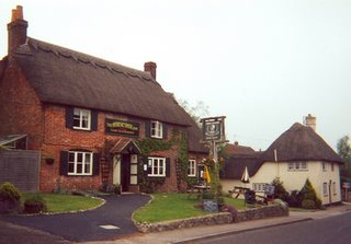
First the print itself: Perhaps there are some still available in Mildenhall. Ask at the Horseshoe Inn there, see ://www.thehorseshoeinn.info/. It once had to close in the 1950's because it had remained open when villagers were supposed to be in church, says the print. We vote it for the best food in England. So there.
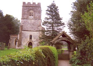
The print shows some obvious things: sketches of prominent landmark buildings like St. John the Baptist Church, two granaries (Church arm and Glebe House), prominent stately homes (Poulton and Woodlands Houses), and a large, rather grand The Old Schoolhouse. Described and listed are local points of interest for prominent people and heroes of wars, tragedies on the spot. A child, for example, killed when a wagon overturned.
B. The Romans
There is a coat of arms on the print for the town, with its Roman name for the 10 years, 50-60 AD, that there was a Roman trading post settlement out here, Cunetio.
- Roman Cunetio: The trading settlement became a walled garrison in about 355 AD. This marked the crossroads of A) the significant West to East way, Bath to Silchester Road (and from there on to London) and b) the smaller, but well-traveled Winchester to Wanborough (is that it? find it at ://homepages.nildram.co.uk/~jimella/wanbrgh.htm) to Cirencester Road (is that it? find it at ://www.cirencester.co.uk/map.htm).
- In the 5th Century, the Romans left, and the garrison shrank away. We did not know all this at the time, but see the copper coins found outside one of the old gates, and there are parts of old mosaic floors said to be just beneath the soil.
- Black Field: There is more to the coins. A large hoard of Roman coins was found at Black Field, see the Cunetio Times Dig Report at ://www.channel4.com/programmes/time-team/articles/cunetio-dig-report/ Find an animation of it on You-Tube at http://www.youtube.com/watch?v=YvbvLwU7Bek/ and scholarly material at the stingy JSTOR that won't let you read more than a whistle before you have to subscribe. Forest Hill: more Roman significance.
- Mindin Hole -- we heard that the Romans found indigenous residents (Celts? Britons?) whose homes were on sunken floors, below ground level for a few feet. Step in, step down. They called them "mind in hole" -- or some such.
C. The Fields
Then the fun starts: a sketch of the town, small cluster of streets, its buildings; and huge area of fields surrounding and extending out with a river through it, like a chunky hump-backed open parenthesis or backwards comma. The name of the river seems to be missing, and we understand it to be the Kennet River. One "t". That is the name that followed with prominent settlers to Pennsylvania in colonial times - Kennett Square; and the Kennett River there, two "t's". The town name went with the Mendenhalls who were among them, and from here - Mildenhall - Mildan-Heall, to Mendenhall over there and also until recently, still in town.
The fields are the history. The Richard Westall-researched names are all there, laid out like a large puzzle.
- Helen Scholes -- this is for you: We still love your print. Why not make a commercial puzzle out of your work here. With all the names, it is more interesting than the knobby repeats we see in stores made from pictures. Put the history sound-bite on the back. Hm? And it would teach all of us whose families by blood or marriage trace rootlets back here, what this area means.
The fields: imagine! And this is just the outer perimeter. Omitted is the great big middle: There is a Wilson there. My husband's mother is Wilson on one side, Mendenhall on the other. Go, genes. All the dozens and dozens and dozens of field names and markers and places where things happened that are memorialized by name or marker
D. Following the Fields around the PERIMETER
Clockwise perimeter, beginning at roughly 12:00 High.
1. Across the top to the right
Broad Drove
Swain's Cottage
Lark Field
Merry Boys - named for students from Marlborough College who helped an Alec Gale there. What was Gale doing? When?
Warren Cottage
Tolterpin Barrage Hill
Blow-a-way
2. Angling down the side
Whitechard - five parishes meet here: Minal, Ogbourne St. Andrew, Ogbourne St. George, Aldbourne, and Ramsbury (the Mendenhalls are buried at Ramsbury)
Smatchams
3. Curling down steeply, all the way toward the bottom
Mere Farm
Mere Paddocks
Mere Barn
Sound Copse
Old Coach Road to London
Sound Bottom - this area has never been plowed. What lies beneath?
Horse Field
Grove Farm
Dairy Block
Rookery
Grove House
Water Meadow
River (the Kennet River - now a syndicated fishery with native brown trout, grayling and pike if you're lucky. Wild fish caught are replenished, preserving the wild stock)
Shepherd Meadow
Stitchcombe Farm
Chalk Pit
Coombe Hill
Oxleaze
Savernake Forest
Puthall Park
4. Across the bottom, right to left now
The A4 motorway to Marlborough goes through here, this way.
Take it the other way and head to London.
The A4 bisects Puthall Park
Amity Oak - about 230 years old. Three parishes meet - Minal, Little Bedwyn, and Brimslayed Cadley
And more of Savernake Forest
Dark Vale
Grand Avenue (coded = = = = for "other tracks")
Red Vein Bottom
Hospital Pieze
Mast Down - there is an Iron Age fort site here. Extra! This has a large rabbit warren. Lots of cowslips in spring.
Elcot
Chopping Knife Lane - it is said that villagers used to chop wood on the common land there
Elcot Water Meadows
Kennet River again - otters are coming back, with some enhancement projects for them going on; also find kingfishers, herons, feeding snipe and sanepipers, swans - same pair of them for 20 years, they say
5. This puts us at about 8:00, heading around and up the backwards comma back to 12:00
Bat Willow Meadow
Codes for bridle paths
Wilsons
Poulton
Poulton Farm
Coding for other tracks
Poulton House
Horse Meadow
Bay Meadow
Linseed
Bay Furlong (a furlong is about 220 yards to us, see ://www.merriam-webster.com/dictionary/furlong)
6. From 10:00 to Noon, going up the top, left to right
Mid Furlong
Abandoned railway track, now a bikeway
Osbourne Hedge
Hollow Ground
Coding for deciduous trees and Old Coach Road to Bath (hedgerows separating fields often contain dense deciduous trees, leaves falling in fall)
Tumulus (artificial hillock, perhaps over a grave, burial mound?)
Coding for earthworks (remains of raised fort areas?)
Stickley
Pennings
More deciduous trees and coding for a by-way
E. Modern Mildenhall
The community website for Mildenhall is at ://www.minal.org.uk/front.htm/ Friday! November 5! 2010! a BBQ with burgers and the fixin's. Very tempting. I bet it will be at the Horseshoe Inn grounds - big lawn area there, gatherings on Sunday afternoons, perpetual Sunday picnics. Is that still so?
 Warwick Castle, Warwickshire, England. Interior display, a war room. Which rebellion?
 Gardens, Leeds Castle, Kent, England
 Stonehenge, Neolithic, Wiltshire, England
 Mildenhall segment, small portion of the "Parish of Minal" calligraphy and illustration print by Helen Scholes 1999. Original colors are more soft melon and early spring green, than this pink and aqua. We are trying to fix, but our equipment is limited.
 Mildenhall, Wiltshire. St. John the Baptist Church. England
 Horseshoe Inn, Mildenhall, Wiltshire, England
 Homes, thatched roofs, Mildenhall, Wiltshire
 Joseph Mendenhall, family originally from Mildenhall
 Bennetts Cross, Dartmoor, Devon, England
